
Słowiński National Park: Dunes, Coastline, and Wetlands
Słowiński National Park occupies a 32,000-hectare strip of the Pomeranian coastline between the towns of Łeba in the east and Rowy in the west. It is listed as a UNESCO Biosphere Reserve and is one of the few places in central Europe where active aeolian processes — wind-driven sand movement — continue to reshape the landscape at a visible pace. The dunes here migrate inland at a rate of 3 to 10 metres per year, burying sections of forest and leaving ghostly white trunks protruding from the sand face.
The dune trail from Łeba
The most direct approach to the moving dunes is from the resort town of Łeba. A 4-kilometre vehicle-free path runs westward from the edge of town along the shore of Lake Łebsko to the dune field. The route is flat and surfaced for the first two kilometres, after which it transitions to an unsurfaced track and then open sand. Allow 90 minutes one way at a walking pace.
The moving dune field is accessible only on foot or by bicycle from Łeba. No motor vehicles are permitted beyond the park boundary gate.
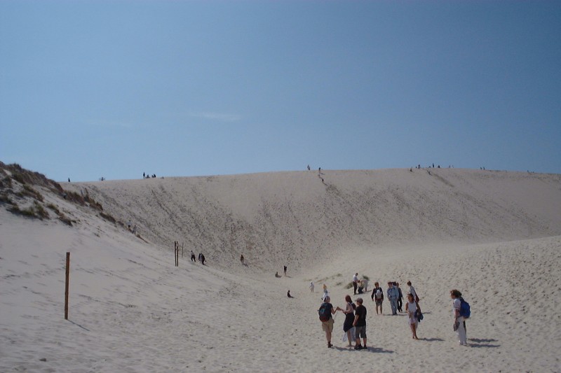
The dune summit area
The highest dune in the active field reaches approximately 42 metres above sea level. From the summit, both the Baltic Sea to the north and Lake Łebsko to the south are visible simultaneously — a perspective that makes the narrowness of the coastal barrier clear. The view west along the dune front, where live sand overlies the ghost forest below, is one of the more unusual landscapes in Poland.
Lake Łebsko and the southern trail system
Lake Łebsko, at 7,140 hectares, is Poland's third largest lake. It is a coastal lagoon formed when a Baltic bay was cut off by sand bar accumulation — still connected to the sea by a narrow channel. The water is brackish, fluctuating with Baltic water levels, and supports a distinct community of aquatic plants including sea club-rush (Schoenoplectus tabernaemontani) and common reed (Phragmites australis) in extensive beds along the eastern and southern shores.
Trail through the reed beds
A blue-marked trail runs along the southern shore of Łebsko from the village of Izbica west to Kluki (approximately 14 kilometres). The path passes through alternating sections of open meadow, alder carr, and dense reed fringe. In spring this stretch is used by nesting bitterns (Botaurus stellaris) — the booming call carries well across still water and is audible from the trail in April and May.
Fauna of the park
Słowiński is one of the most significant wetland bird areas in Poland. The park and its coastal waters host regular breeding populations of white-tailed eagle, marsh harrier (Circus aeruginosus), great bittern, and common crane. During autumn migration the lake shore at Kluki is a staging point for large numbers of geese — primarily bean goose (Anser fabalis) and greater white-fronted goose (Anser albifrons) — sometimes numbering in the thousands.
Mammal diversity is lower than in the inland forests to the south, but harbour porpoise (Phocoena phocoena) are occasionally seen in the nearshore Baltic waters off the dune front, particularly in calm conditions between October and December. Roe deer (Capreolus capreolus) and wild boar (Sus scrofa) use the forest strips between the dune field and the lake.
Western section: Rowy to Gardna Lake
The western end of the park around the village of Rowy is less visited. A red-marked trail connects Rowy to the Gardna Lake system over approximately 20 kilometres of mixed terrain: open dune, mature beech forest (unusual at this elevation on the coast), and boardwalk sections over boggy ground. The Gardna and Łebsko lakes are connected by a 14-kilometre canal, the Łeba-Gardna waterway, originally built in the 18th century and passable by kayak in summer.
Practical notes
- Entrance to the dune zone costs a park fee payable at the gate (current rates on slowinskipn.pl)
- Dogs are not permitted on the dune trail or the strict nature reserve sections
- Walking on dune vegetation is prohibited — the park authority monitors compliance during summer
- The coastal Baltic path is fully exposed to wind; bring windproof clothing regardless of the forecast
- Nearest rail station: Łeba, served by seasonal trains from Słupsk (journey 45 minutes)
For park regulations, current trail closures, and seasonal permit information, consult the official park administration at slowinskipn.pl.

